 |
 |
 |

|
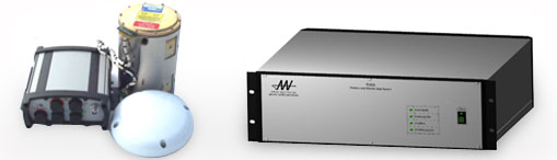
PurposeThe Position and Attitude Data System (PADS) is a high accuracy, near real time, long range airborne direct georeferencing system. It integrates GPS and inertial sensor measurements using Kalman filtering techniques to precisely determine multiple target locations on the ground. It consists of an Inertial Measurement Unit (IMU), GPS receiver, and Integration Computer System (ICS) running the Applied Analytics Real Time Navigator (RTN) software package. FeaturesHardware/software for precision roll, pitch, heading and navigation Complete inertial navigation solution at IMU data rate (e.g. 200Hz, WGS-84) Initial heading and leveling alignment accomplished with Kalman Filter In-air alignment capability (re-start) Navigator calibrated with Multi-State Kalman filter using GPS observations UTC event timing to 1 microsec System DescriptionKearfott KI-4901 Inertial Measuremment Unit NovAtel ProPak-LB GPS system using Omnistar to achieve <0.2 m accuracy in real time QNX operating system Standard RS-422 IMU interface with data validity interrupt PADS/C, Ethernet controller Data can be collected for Post processing Removable I/O panel Swappable 1-36 VDC Volt Lambda Power Supply. Industry standard VME power can be replaced with alternative units using any input power Easy to Read Power Supply Status Lights Removable/Replaceable Euro Card GPS receiver Space for additional 4HP Euro Card (Optional) Fully Functional Computer uses Ampro LB700 EBX processor with Sealevel PC-104 8 port communications Robust I/O connection availability. (6) External (6) internal RS-232/RS-422 Serial Communication Ports, (4) USB A1.1 Compliant Ports, (2) RJ-45 10/100 Network Ports AccuracyPitch/Roll 0.003 deg, Heading 0.004 deg (real-time) Position < 20 cm (real-time) All navigation data at 200 Hz Event timer allows for precise coupling with optical and multi-spectral sensors
GPS, GPS Antenna, IMU and Integration Computer System (ICS) |
||||||||


Copyright Applied Analytics, Inc. All rights reserved